
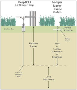
Wetland elevation dynamics hinge on the intricate interplay between subsidence and accretion processes. Subsidence includes several local factors that contribute to the gradual lowering of wetland elevation such as compaction and consolidation of sediments, occurring both in shallow and deep layers, tectonic activity influencing the geological framework, and human-induced impacts like the withdrawal of oil and gas. These various elements collectively shape the subsidence profile of a wetland, highlighting the dynamic nature of the landscape.
Accretion, Subsidence and Sea Level Rise
Conversely, accretion denotes the vertical buildup of soil on the wetland surface, a measurable phenomenon often tracked using markers like feldspar. This accumulation process plays a pivotal role in maintaining wetland elevation and countering the effects of subsidence. The combination of eustatic sea-level rise and subsidence is encapsulated in the concept of Relative Sea-Level Rise (RSLR), a critical metric for understanding the overall changes in wetland elevation over time.
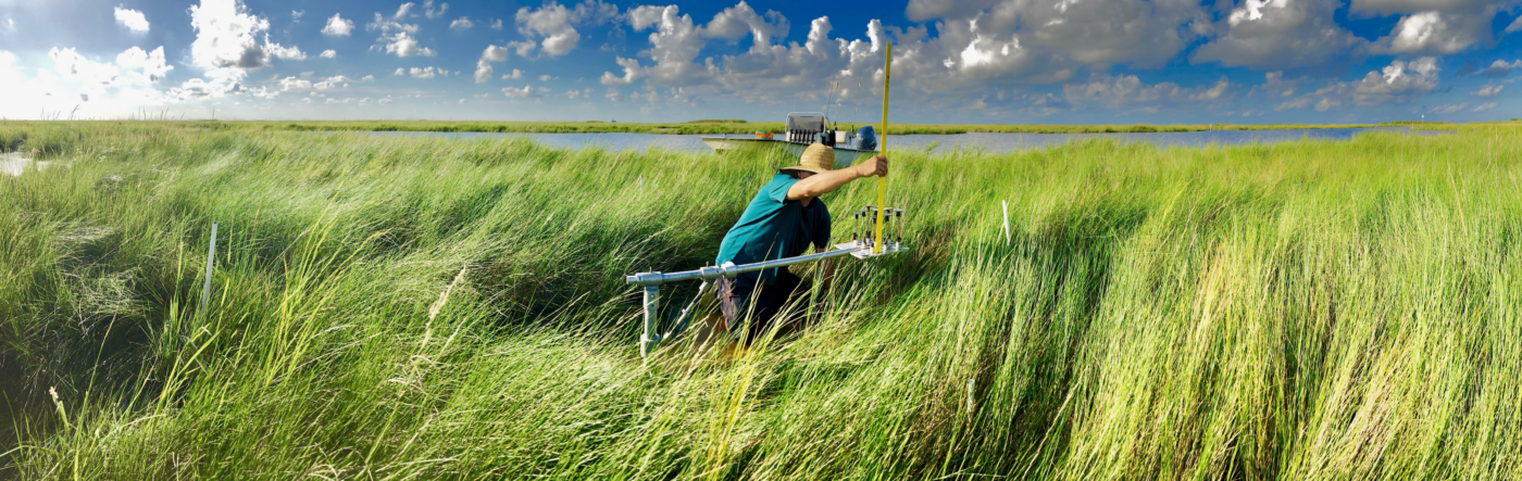
The Surface Elevation Table-Marker Horizon Method
Achieving long-term stability in wetland ecosystems necessitates that the gain in wetland surface elevation equals or surpasses RSLR. This equilibrium is crucial for preserving the intricate balance of these ecosystems in the face of environmental challenges. The Surface Elevation Table-Marker Horizon (SET-MH) method (i.e., rSET) emerges as a valuable tool in this context. This method allows for the simultaneous measurement of both wetland surface elevation change and surface accretion, offering a comprehensive understanding of the factors influencing the wetland elevation dynamics.
Utilizing the SET-MH method provides insights into the local estimates of relative sea-level rise (RSLR) and submergence potential. By quantifying elevation change and shallow subsidence through this method, researchers and environmental practitioners can better comprehend the nuanced interactions shaping wetland landscapes. This knowledge becomes instrumental in formulating effective conservation and management strategies to safeguard these critical ecosystems against the backdrop of ongoing environmental changes.
Further Reading:
https://comiteres.com/wp-content/uploads/2023/01/Lane-et-al.-2020.pdf
https://comiteres.com/wp-content/uploads/2018/10/Lane-et-al.-2006.pdf