CHS Monitoring

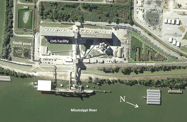
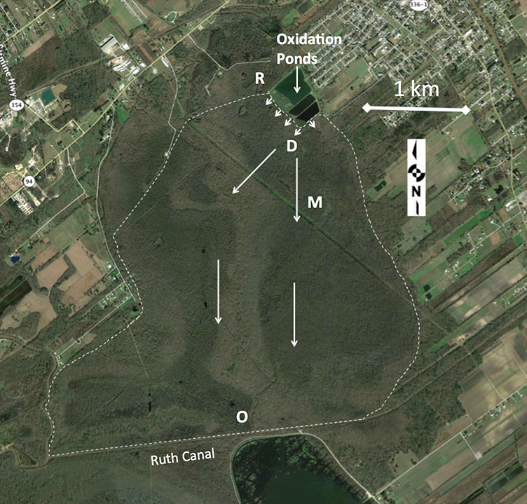
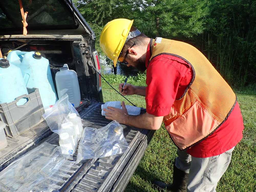
Comite Resources designed two stormwater wetlands directly north and south of CHS, Inc. bulk grain transfer terminal, which handles both grain and grain by-products. The facility transfers grain from barges to ocean going vessels and services about 2 to 3 ships per day. Because of the high volume of grain handled by the facility, grain dust and spilled grain is deposited on the site and washed into the stormwater system. To address this problem, CHS partnered with Comite Resources to construct two wetlands totaling 2.5 acres to reduce total organic carbon (TOC) from stormwater runoff. Herbaceous species were planted and also colonized the area naturally, and baldcypress seedlings were planted at a density of 200 per acre, for a total of 500 trees. Hillman et al. (2018) reported a mean diameter growth increase of 2.5 cm/yr for these seedlings, which is very high. The use of wetlands to remove pollutants from stormwater runoff has great potential as a cost- and energy efficient method of improving water quality while also providing habitat for wildlife (see Stormwater Wetlands). The CHS stormwater wetlands have many species of birds living in the wetlands along with alligators, fish and frogs. Comite Resources visits CHS stormwater wetlands quarterly to carry out stormwater wetlands assessment and environmental monitoring to assess TOC reduction efficiency, vegetation growth, and overall health and system performance. Below are monitoring reports from this site describing work carried out and preliminary data.

Imagery of the CHS facility with the stormwater wetlands, labeled as North and South ponds, located on either side of the facility.

St. Martinville Monitoring

The city of St. Martinville began discharging treated effluent from the city wastewater treatment facility to the Cypress Island Coulee wetlands in 2011. The treatment facility has a maximum design flow of 1.5 million-gallons-per-day, and consists of a 63.7 ha facultative lagoon with ultraviolet disinfection and a cascade aeration structure. The Cypress Island Coulee wetlands are located adjacent to the treatment facility and consist primarily of water tupelo, baldcypress, and swamp red maple. These wetlands have been degraded by conversion of surrounding areas to rice and crawfish ponds, and now consist of a number of shallow ‘ponds’ separated by low levees. Treated effluent is discharged at six different locations and surface water drains into the Cypress Island Coulee after flowing through the wetlands. Comite Resources has been carrying out wetlands assessment of the site since it was officially permitted in 2011. Environmental monitoring includes measurements of tree growth (dbh & leaf) and productivity, water hydrology, soil accretion, and nutrients and metals concentrations of surface waters, soils and vegetation. In order to monitor the effects of this discharge on the vegetation of the receiving wetlands, several sets of study sites (Discharge, Mid, and Out) were established, as well as three Reference sites located in nearby wetlands. Comite Resources visits these sites monthly to carry wetlands assessment and environmental monitoring. Below are monitoring reports from this site describing work carried out and preliminary data.

Results from several ongoing and completed studies of wetland assimilation systems in Louisiana indicate that they are achieving the ecological goals of enhancing water quality, stimulating vertical accretion, and increasing productivity. At low loading rates, nutrient reductions are high, often greater than 80%, due to plant uptake, denitrification, and burial. There are substantial economic and energy savings for small communities and non-toxic industrial processors. Wetland assimilation can provide an economically viable, effective and sustainable alternative to expensive conventional tertiary treatment while also providing wetland restoration in a subsiding coastal zone.

Location of wetland monitoring sites at the St. Martinville assimilation wetlands. Ref = Reference site, D = Discharge site, M = Mid site, and O = Out site.

Breaux Bridge Monitoring

The city of Breaux Bridge began discharging treated effluent into the Cypriere Perdue Swamp starting in 1954 when a city-wide sewage collection system and wastewater treatment plant were constructed.  The city uses a 3-stage oxidation pond and chlorination-dechlorination disinfection system with the capacity to treat 1.27 million-gallons-per-day prior to discharge to the wetlands. The 1470-ha swamp wetlands are dominated by very large baldcypress, water tupelo, and swamp red maple trees, as well as black willow and tallow in some disturbed areas. The wetland is hydrologically bounded to the east, north, and west by natural levees, and drains into Ruth Canal that forms the southern boundary and connects to Bayou Teche and the Vermillion River. Comite Resources has been carrying out wetlands assessment of the site since it was officially permitted in 1997. Monitoring includes measurements of tree growth (dbh & leaf) and productivity, water hydrology, soil accretion, and nutrients and metals concentrations of surface waters, soils and vegetation. These measurements are made at permanent plots located in the forest directly impacted by the effluent (termed the Discharge site), where the surface water exits the assimilation wetland (termed the Out site), and a site in between these two sites (termed the Mid site; Hunter et al. 2018). A nearby Reference site that is not impacted by the effluent is also monitored for comparison. Below are monitoring reports from this site describing work carried out and preliminary data.

The Cypriere Perdue Swamp is a healthy forested wetland that has been assimilating nutrients from treated municipal effluent for nearly six decades with no apparent negative impacts to ecosystem function or water quality. Many forested wetlands in Louisiana are in a degraded condition due to impoundment and subsidence, and outside sources of nutrients are needed to increase productivity, organic matter deposition, and subsequent accretion. Treated effluent can be a valuable source of nutrients and suspended material for degraded wetlands in coastal Louisiana.

Location of wetland monitoring sites at the Breaux Bridge assimilation wetlands, also known as the Cypriere Perdue Swamp. R = Reference site, D = Discharge site, M = Mid site, and O = Out site. The small arrows indicate discharge locations, the large arrows indicate water flow, and the dashed line delineates the boundary of the assimilation wetland. The Reference site was moved after the permit was issued because the number of discharge points increased from one to five.