Why rSETs are Important for Wetland Monitoring

Wetland elevation dynamics hinge on the intricate interplay between subsidence and accretion processes. Subsidence includes several local factors that contribute to the gradual lowering of wetland elevation such as compaction and consolidation of sediments, occurring both in shallow and deep layers, tectonic activity influencing the geological framework, and human-induced impacts like the withdrawal of oil and gas. These various elements collectively shape the subsidence profile of a wetland, highlighting the dynamic nature of the landscape.

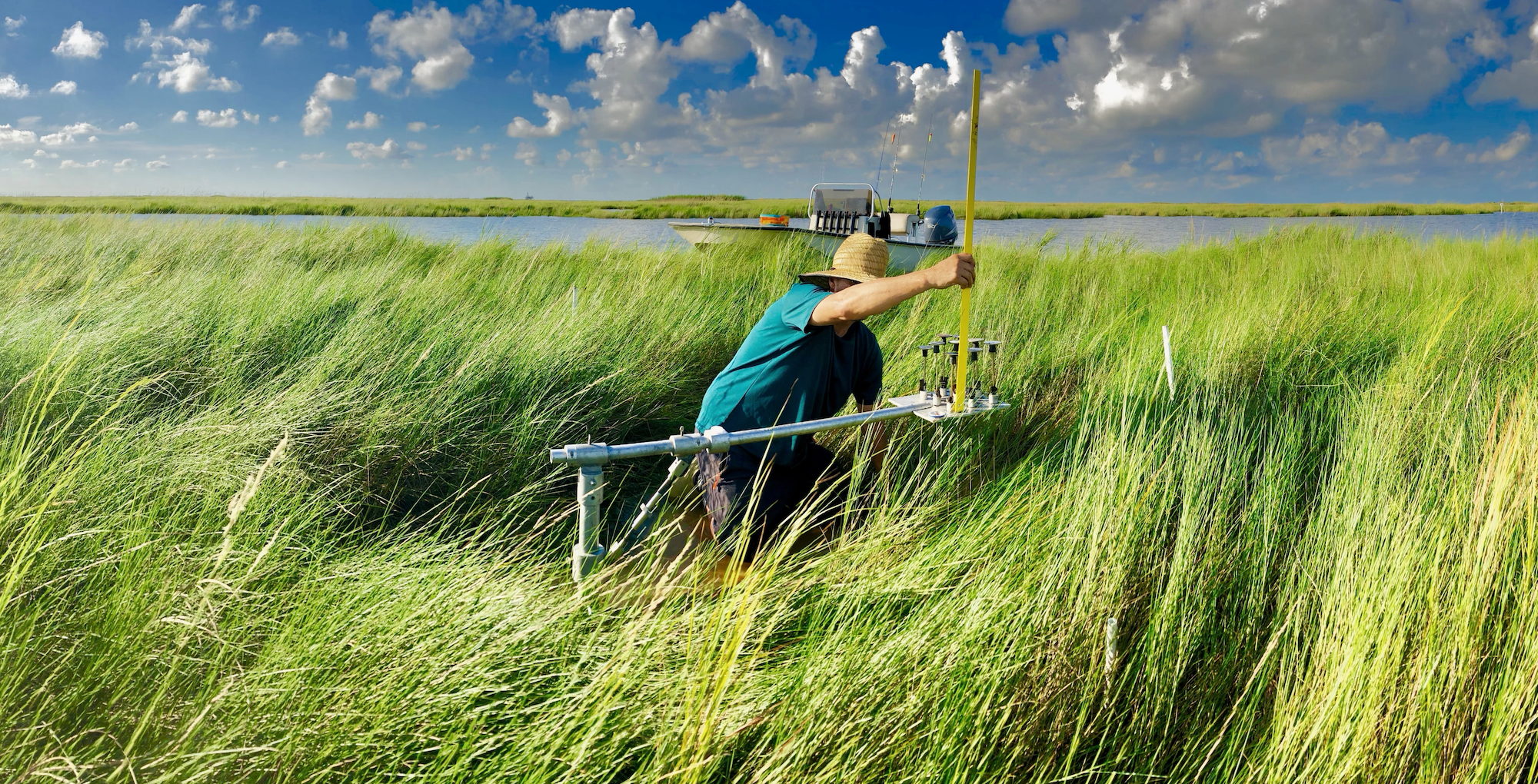
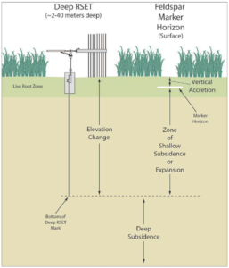
Shows profile of rSET benchmark with instrument mounted on top and pins lowered to the wetland surface. Accretion markers are shown with accumulated soil material on top.
The combined Surface Elevation Table – Marker Horizon technique enables estimates of both above and below-ground process contributions leading to wetland elevation change (from Lynch et al. 2015).

Accretion, Subsidence and Sea Level Rise

Conversely, accretion denotes the vertical buildup of soil on the wetland surface, a measurable phenomenon often tracked using markers like feldspar. This accumulation process plays a pivotal role in maintaining wetland elevation and countering the effects of subsidence. The combination of eustatic sea-level rise and subsidence is encapsulated in the concept of Relative Sea-Level Rise (RSLR), a critical metric for understanding the overall changes in wetland elevation over time.

The Surface Elevation Table-Marker Horizon Method

Achieving long-term stability in wetland ecosystems necessitates that the gain in wetland surface elevation equals or surpasses RSLR. This equilibrium is crucial for preserving the intricate balance of these ecosystems in the face of environmental challenges. The Surface Elevation Table-Marker Horizon (SET-MH) method (i.e., rSET) emerges as a valuable tool in this context. This method allows for the simultaneous measurement of both wetland surface elevation change and surface accretion, offering a comprehensive understanding of the factors influencing the wetland elevation dynamics.

Utilizing the SET-MH method provides insights into the local estimates of relative sea-level rise (RSLR) and submergence potential. By quantifying elevation change and shallow subsidence through this method, researchers and environmental practitioners can better comprehend the nuanced interactions shaping wetland landscapes. This knowledge becomes instrumental in formulating effective conservation and management strategies to safeguard these critical ecosystems against the backdrop of ongoing environmental changes.

Further Reading:

https://comiteres.com/wp-content/uploads/2023/01/Lane-et-al.-2020.pdf

https://comiteres.com/wp-content/uploads/2018/10/Lane-et-al.-2006.pdf

Wetland Delineations

What is a Wetland Delineation?

A wetland delineation determines the boundary between uplands and wetlands on a property following guidelines established by the United States Army Corps of Engineers (USACE). It involves identifying, characterizing, and mapping wetlands based on soil, vegetation and hydrologic characteristics. The process of delineation involves a combination of fieldwork, data analysis, and consultation with regulatory agencies. In the field, a skilled wetland scientist evaluates the site’s characteristics for key indicators such as wetland hydrology, hydric soils and hydrophytic vegetation, which define wetland ecosystems (See “What is a Wetland?”). These findings are then meticulously mapped and documented to delineate the precise boundaries of the wetlands on the property.

Why Do I Need a Wetland Delineation?

Because of their benefits (e.g., habitat, water quality improvement, stormwater storage, carbon sequestration), wetlands are important and regulated ecosystems in the United States. The U.S. Environmental Protection Agency (EPA) generates and enforces policies that avoide or minimize adverse impacts to wetlands when possible. A wetland delineation is needed whenever there is a potential impact on wetland areas due to land development projects. By identifying and mapping wetland boundaries accurately, stakeholders can make informed decisions that prioritize the conservation and sustainable use of these vital ecosystems.

A wetland delineation is also necessary if an activity negatively impacts a wetland to determine the amount of “compensatory mitigation” needed.  Compensatory mitigation could mean several things:

    • Restoration: Re-establishing or rehabilitating a degraded wetland.
    • Establishment: Creating a new wetland where one did not previously exist;
    • Enhancement: Improving existing one or more wetland functions; or
    • Preservation: Using legal and physical mechanisms to protect or enhance an existing, ecologically important wetland.

As a developer or project decision-maker, wetland delineation and its potential findings may appear daunting. Here are some common concerns and why they might be causing unnecessary worry:

  1. Limited Expertise: Wetland delineation demands specialized knowledge and skills. Collaborating with an experienced consultant can help alleviate uncertainties and ensure precise determination of wetland boundaries.
  2. Regulatory Complexity: The rules governing wetland delineation and permitting can be intricate and difficult to decipher. Partnering with a consultant well-versed in regulatory compliance and environmental permitting is essential for success.
  3. Time Constraints: Tight project schedules can amplify the pressure. Recognizing the significance of meeting deadlines is crucial, along with harnessing cutting-edge technology and tools to enhance efficiency and accuracy.
  4. Cost Considerations: Wetland delineation may seem like an added expense, particularly for larger projects. However, investing in this process upfront can prevent substantial costs and complications later on if a wetland that was not known about is disturbed during construction.
  5. Potential for Disruptions: Delineations may reveal previously unidentified wetland boundaries, potentially causing delays or interruptions during permitting. Addressing these discoveries early is key to minimizing project disruptions.

The process of identifying and delineating wetlands is complex. Contact Comite Resources, an environmental consulting company with a knowledgeable and experienced staff, to provide expertise and support throughout the entire process.

Why Do I need a Phase 1 Environmental Site Assessment?

A Phase 1 Environmental Site Assessment (ESA) is a critical and standard practice in real estate transactions, particularly when purchasing or financing commercial properties. This assessment plays a crucial role in identifying potential environmental liabilities associated with a property, offering invaluable insights for all parties involved in the transaction. The key reasons that that a Phase 1 ESA might be needed include:

  1. Securing Financing
  2. Regulatory Compliance
  3. Shield Against Liability
  4. Risk Management

One of the primary reasons for undertaking a Phase 1 ESA is its often-mandatory requirement for securing financing from lending institutions. Banks and financial entities seek assurance that the property being invested in doesn't harbor hidden environmental issues that could translate into financial risks down the road. By initiating a Phase 1 ESA early in the due diligence process, potential environmental concerns can be unearthed, allowing for well-informed decision-making by all involved parties.

The Phase 1 ESA serves as a crucial tool for ensuring regulatory compliance. It aids property buyers and developers in adhering to environmental regulations stipulated by agencies such as the Environmental Protection Agency (EPA). Failure to identify environmental liabilities can lead to legal and financial consequences. The assessment, by ensuring compliance with applicable environmental laws, acts as a preventive measure against these risks.

Additionally, the Phase 1 ESA acts as a protective shield against potential liability under the Comprehensive Environmental Response, Compensation, and Liability Act (CERCLA), commonly known as the Superfund law. Should environmental contamination be discovered at a later stage, having conducted a Phase 1 ESA provides a potential defense against being designated as a responsible party for the contamination, provided the assessment adhered to established standards.

Beyond compliance and liability protection, the Phase 1 ESA serves as a valuable tool for risk management. It offers stakeholders a comprehensive understanding of the environmental history of a property, encompassing its past uses and any potentially hazardous activities that may have transpired. With this information, stakeholders can make well-informed decisions regarding property acquisition, development, and ongoing operations, thereby minimizing the risk of unforeseen environmental issues.

In summary, a Phase 1 Environmental Site Assessment stands as an indispensable component of due diligence in real estate transactions. It furnishes crucial information for financial institutions, buyers, and developers, facilitating informed decision-making, ensuring regulatory adherence, managing environmental risks, and safeguarding against potential liabilities associated with the property in question. Embracing this assessment early in the process is not just a best practice; it's a strategic imperative for a robust and risk-aware approach to real estate transactions.


Why Do I need a Permit to Build on Wetlands?

Requiring a permit to build on jurisdictional wetlands is a crucial aspect of environmental conservation and sustainable land use management. Wetlands play a vital role in maintaining ecological balance, providing habitat for diverse plant and animal species, improving water quality, and offering flood control. The need for a permit stems from the recognition that unregulated development in these sensitive areas can have significant and often irreversible impacts on the environment. In this blog post, we’ll delve into the why behind the need for permits and how they serve as guardians of these vital natural landscapes.

  1. Ecological Importance of Wetlands: Before we explore the intricacies of permits, it’s essential to understand why wetlands merit such stringent regulatory measures. Wetlands contribute significantly to ecological balance—they provide habitats for diverse plant and animal species, enhance water quality, and act as effective flood control mechanisms. Recognizing their irreplaceable role in the environment, various local, state, and federal regulations are in place to safeguard wetlands.
  2. Regulatory Oversight by Environmental Agencies: Agencies such as the Department of Environmental Quality (DEQ) and the Environmental Protection Agency (EPA) establish guidelines to ensure responsible usage and preservation of wetland ecosystems. Requiring a permit serves as a regulatory mechanism to evaluate proposed developments in or near jurisdictional wetlands, assessing potential environmental impacts and implementing measures to mitigate adverse effects.
  3. Comprehensive Review Process: Obtaining a permit involves a comprehensive review of the proposed project. This process considers factors such as wetland delineation, potential disturbance to habitat, changes in hydrology, and impacts on water quality. This careful evaluation helps regulatory authorities make informed decisions to balance human development needs with the protection of wetland ecosystems.
  4. Mitigation Measures and Sustainable Development: Permitting also allows for the incorporation of mitigation measures to offset any unavoidable impacts on jurisdictional wetlands. Developers may be required to implement strategies like creating new wetlands, restoring degraded ones, or establishing buffer zones to minimize the ecological consequences of the project. This approach aims to strike a balance between development and environmental conservation, ensuring that wetlands continue to provide their essential ecological functions.
  5. Preserving Biodiversity and Ecosystem Health: The requirement for a permit functions as a critical tool for sustainable land management. It acts as a safeguard against uncontrolled development that could lead to the degradation or loss of valuable wetland ecosystems. By navigating the permitting process, developers become active contributors to the broader goal of preserving biodiversity, maintaining water quality, and safeguarding the long-term health of these ecologically significant areas.

Ultimately, the permit requirement serves as a critical tool for sustainable land management. It helps prevent uncontrolled development that could lead to the degradation or loss of valuable wetland ecosystems. By obtaining a permit, developers contribute to the broader goal of preserving biodiversity, maintaining water quality, and safeguarding the long-term health of these ecologically significant areas.


What is a Wetland?

A wetland is an area where water is present either on the soil surface or within the plant root zone for a portion of the year and contains vegetation adapted to wet soils. Wetlands are diverse ecosystems that bridge the gap between terrestrial and aquatic environments. They’re incredibly important because they provide habitat for a wide variety of plant and animal species, help control flooding by absorbing excess water, improve water quality by removing pollutants such as excess nutrients, and help maintain biodiversity.

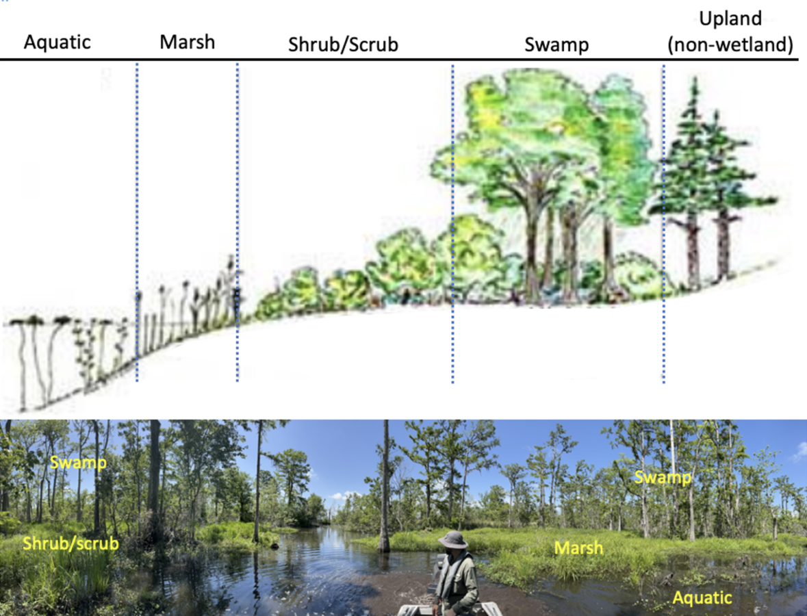
Wetlands include marshes, swamps, bogs, and areas along water bodies such as bayous or lakes. Wetlands dominated by trees are called swamps and wetlands dominated by herbaceous (i.e., non-woody plants) plants are called marshes. Wetland vegetation species distribution is determined by hydrology, specifically length and depth of soil surface flooding.  A typical wetland will emerge from an adjacent water body into the shallow aquatic zone where floating or rooted plants grow to the marsh zone where herbaceous (non-woody) plants grow.  Beyond the marsh, at a slightly higher elevation, may be a shrub/scrub area with short woody and herbaceous vegetation that, grades to swamp dominated by bald cypress trees at lower elevations and longer flooding times.

(top) Schematic of idealized freshwater wetland zonation. (bottom) Actual freshwater wetland zonation in a coastal Louisiana wetland.

There are seven major types of wetlands, classified as either coastal or inland, in the United States. These wetlands exhibit considerable diversity due to variations in soil type, topography, climate, hydrology, water chemistry, vegetation, and various other factors. They support a rich biodiversity and span across diverse landscapes and range from the icy tundra to the lush tropics, and are present on every continent except Antarctica.


Wetland Type Dominant Vegetation Dominant Hydrology
Coastal Wetlands
 

Tidal Salt Marsh

Herbaceous – ex: smooth cordgrass  

Tidal

Tidal Freshwater Marsh Herbaceous – ex: maiden cane Tidal
Mangroves Woody – Mangrove trees Tidal
Inland Wetlands
 

Inland Freshwater Marsh


Herbaceous – ex: cattails

Rivers, streams, precipitation, watershed runoff
Northern Peatlands Herbaceous – ex: moss Precipitation
 

Southern Deepwater Swamps

Woody – ex: bald cypress, water tupelo Rivers, streams, precipitation, watershed runoff
 

Riparian Wetlands

Woody – shrubs and trees, ex: buttonbush and willow, Rivers, streams, precipitation, watershed runoff


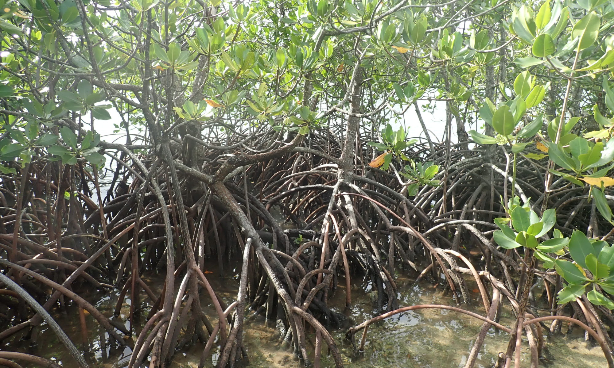
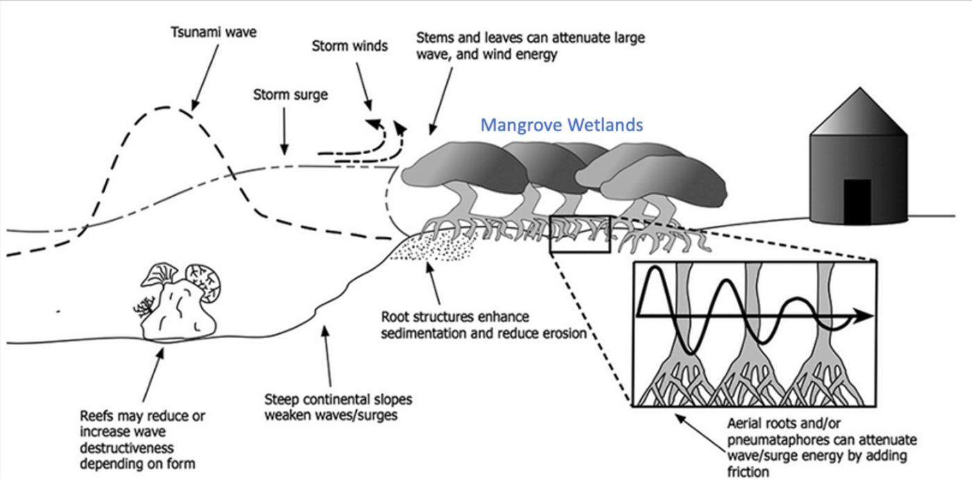
Wetlands are important and diverse ecosystems that provide economic benefits to society.  For example, coastal mangrove wetlands can protect houses from intense wind and storm surge (Figure 2).

Figure 2. Coastal forested wetlands provide protection from wind and storm surge (Image from D. E. Marois and W.J. Mitsch (2015). Coastal protection from tsunamis and cyclones provided by mangrove wetlands – a review. International Journal of Biodiversity Science, Ecosystem Services & Management 11:1:71-83, DOI: 10.1080/21513732.2014.997292.

State and federal legislation, such as Section 404 of the Clean Water Act (CWA), exists to protect wetlands.  Wetlands determined to be ‘jurisdictional wetlands’ (as delineated using Section 404 of the CWA) have their uses regulated by agencies such as the U.S. Army Corp of Engineers, including wetlands on private property.  So, What is a jurisdictional wetland?  Sign up to receive additional information.