St. Charles Monitoring

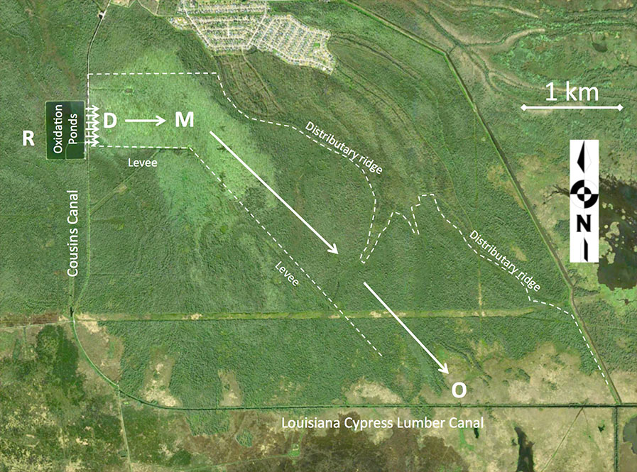
St. Charles Parish has been using wetlands assimilation since 2008. The wastewater treatment facility consists of a facultative oxidation pond with a chlorination and dechlorination disinfection system with an average discharge of 1.6 million-gallons-per-day. Before 2008, the treatment plant discharged into Cousin Canal, which drains into Lake Cataouatche via the Louisiana Cypress Lumber Canal. Starting in 2008, the treated municipal effluent was piped approximately 150 ft to a 1439 ha cypress-tupelo dominated forested wetland. Effluent is retained within the project boundaries by low-lying levees running along the northern, eastern, and western boundaries that prevent hydrological exchange with the surrounding landscape, except at the southern most extent of the project area where water flows out of the project area into the Louisiana Cypress Lumber Canal and then to Lake Cataouatche.

Comite Resources carried out a carbon sequestration study at the St. Charles assimilation wetlands. Changes in carbon stocks of trees and soils as well as methane and nitrous oxide emissions were measured over a one-year period and compared to baseline conditions derived from the scientific literature (see Carbon Sequestration). Methods and equations were applied from the American Carbon Registry (ACR) wetland carbon offset methodology ‘Restoration of Degraded Deltaic Wetlands of the Mississippi Delta’. The results of the study demonstrate that wetland assimilation increases wetland productivity and enhances carbon sequestration. See Lane et al. 2017 for the peer-reviewed scientific study.

Comite Resources has been carrying out wetlands assessment of the site since effluent was diverted into the wetlands in 2008. Monitoring includes measurements of tree growth (dbh & leaf) and productivity, water hydrology, soil accretion, and nutrients and metals concentrations of surface waters, soils and vegetation. These measurements are made at permanent plots located in the forest directly impacted by the effluent (termed the Discharge site), where the surface water exits the assimilation wetland (termed the Out site), and a site in between these two sites (termed the Mid site), as well as a nearby Reference site that is not impacted by the effluent for comparison (see Hunter et al. 2009b and Hunter et al. 2018). Below are monitoring reports from this site describing work carried out and preliminary data.

Location of wetland monitoring sites at the St. Charles assimilation wetlands. R = Reference site, D = Discharge site, M = Mid site, and O = Out site.


Hammond Monitoring

The Hammond assimilation wetlands consist of 121 ha of mostly emergent wetlands located just north of the Joyce Wildlife Management Area, which encompasses about 14,000 ha. Once effluent exits the assimilation wetlands it then flows through this much larger wetland complex. Hammond’s treatment system has a design capacity of 8 million-gallons-per-day with a three-cell aerated lagoon. A 1.2 km effluent distribution system disperses effluent along the northern edge of the assimilation wetlands.

The Joyce Wildlife Management Area used to be a thriving cypress-tupelo forested wetland (see Shaffer et al. 2015). During the past century and a half, there have been a number of significant modifications to the landscape that substantially altered the hydrology of the region (see Lane et al. 2015). Now most trees are dead due saltwater intrusion and the lack of freshwater, and the area has converted to emergent wetlands dominated by smooth cordgrass (Spartina alterniflora). The living cypress that are left are confined to the northern reaches where the addition of municipal effluent has created a freshwater buffer that counters higher salinities coming from the south. Comite Resources planted several hundred cypress seedlings directly in the path of the municipal effluent over a decade ago, and now these trees are growing very fast at 2 cm/yr in diameter (see Hillman et al. 2018).

Comite Resources has been carrying out wetlands monitoring at the Hammond assimilation wetlands since discharge began in 2006. Monitoring includes measurements of tree growth (dbh & leaf) and productivity, water hydrology, soil accretion, and nutrients and metals concentrations of surface waters, soils and vegetation. These measurements are made at permanent plots located in the area directly impacted by the effluent (termed the Discharge site, taken at the boardwalks), where the surface water exits the wetland complex (termed the Out site), and a site in between these two sites (termed the Mid site). Since the Mid site is forested and the Discharge and Out sites are emergent wetlands, there are two Reference sites, an emergent and forested, not impacted by the effluent. Below are monitoring reports from this site describing work carried out and preliminary data.

Location of wetland monitoring sites at the Hammond assimilation wetlands. D = Discharge site, M = Mid site, and O = Out site, Rf = Forested Reference site, Re = Emergent Reference Site.